Oceanographic Conditions
 Fishscape incorporates satellite imagery, field survey data and global circulation models to generate realistic oceanographic conditions for the Eastern Pacific Ocean. The resulting oceanographic model works in tandem with models of fish population dynamics and fisher behavior to generate a strong and robust model of the Eastern Pacific tuna fishery.
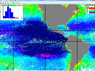
Satellite imagery currently available and integrated into Fishscape includes sea surface temperature, sea surface height, wind and weather conditions, chlorophyll, solar insolation and ocean circulation. In the future, Fishscape will also include the option to automatically go online and update associated satellite imagery archives to maintain up-to-date oceanographic data.
Data from field surveys of nutrients, temperature, mixed layer depth, oxygen and chlorophyll are also integrated into the project to aid in fine-tuning primary production algorithms, tuna habitat preferences, school sizes, fish recruitment and FAD (fish aggregation device) clusterings.
Output from NASA’s ECCO2 global circulation model, which includes 3-dimensional fields of horizontal and vertical flow velocities, temperature, sea surface height and mixed layer depth, will also be used to generate and predict appropriate oceanographic conditions for future analyses.